
Rowley-CanadaOn this page is reproduced a section of an ancient map published after the settlement of the boundary dispute. This map, covering the part of New Hampshire west of the Merrimack River and including a part of the present state of Vermont, was evidently compiled from township surveys made before 1748. Some of these townships are not drawn correctly, and not all are correctly placed, but it may be accepted as an approximate representation of conditions in the region immediately around Monadnock after the settlement of the boundary controversy in 1740. On this map the Grand Monadnock, not being within the limits of any township then surveyed, is omitted. Its true place is south of the Monadnock hills. 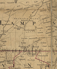
The dotted line south of Rowley Canada represents the newly established boundary line between the provinces, and the solid east and west line through the township of Peterborough is in the approximate position of the boundary previously proposed by New Hampshire. The name Petersburg, which appears north of Peterborough on the map, is occasionally found in early records in place of the name Peterborough, of which it is probably only a variant. Among the errors that may be noted, the names of New Ipswich and Ipswich (Canada), now Winchendon, Massachusetts, are transposed; Peterborough and Rowley Canada are not drawn in their true positions, and the latter not in its correct proportions. East of Ipswich will be noticed Groton Gore, to which reference is made in a succeeding chapter on pastures. Among the townships delineated upon this ancient map of particular interest in our history is Rowley Canada which occupied in large part the area now covered by Jaffrey and Rindge. This was one of the several so-called Canada townships granted to the soldiers, or their descendants, who served under Sir William Phipps, a soldier of fortune and popular hero of the day, in a disastrous military expedition against Canada undertaken by the Colony of Massachusetts in 1690. The expense of the venture, which brought only loss to the colony, was first paid by an emission of paper money, which soon depreciated and became of little or no value. In the course of years the sufferers from the depreciated currency began to petition the General Court to make good their losses. In the era of expansion during the boundary controversy, Massachusetts found an opportunity to liquidate the long troublesome debt for military service, and gain a foothold by occupancy in the disputed territory by granting townships beyond the boundary claimed by New Hampshire, particularly in territory west of the Merrimack River. In this movement speculators also saw an opportunity for profit, and leading members of the General Court did not hesitate to use their official influence in their own interest as claimants for new townships. Most of the townships granted for the Canada service received names which compounded that of the town from which the service was rendered with that of Canada, as Ipswich Canada, represented among present-day towns by Winchendon, Massachusetts, granted to descendants of Ipswich soldiers in the Canada expedition; Dorchester Canada, in modern terms the town of Ashburnham, Massachusetts, granted to soldiers from Dorchester; and others in similar form. In this enterprise, Colonel Thomas Berry, a physician of Ipswich, and a member of the Council, was active in securing grants of townships in the vicinity of Monadnock. In the same way the Salem soldiers were rewarded by a grant of land known as Salem Canada, now the town of Lyndeborough, New Hampshire, and named for another eminent member of the Massachusetts General Court, Benjamin Lynde. Rowley Canada was granted in 1736 to John Tyler, Joseph Pike and fifty-nine others, either officers or soldiers in the Canada expedition of 1690, or descendants of those deceased. The grantees were nearly all from Rowley, Topsfield, Boxford and other towns in Essex County, Massachusetts, which were parts of the original town of Rowley. Among the grantees were some of the leading men of the time in public life of the Massachusetts colony. John Tyler, a grandson of Job Tyler the pioneer ancestor of the family in America, was born in Rowley Village, afterward Boxford, September 14, 1669. He was for many years a sea captain, but after retiring from this service, lived on the homestead of his father in Boxford, near the Andover line, where he was a member and deacon of the North Andover church. The Tyler homestead remained in the family two and a third centuries, until 1885. Joseph Pike of Newbury, born 1674, died 1757, is said by the historian of Hillsborough, N. H., to have been the first to explore the Contoocook River from its mouth to its source on Monadnock, an adventure which presumably accounted for his interest in the promotion of the township of Rowley Canada. He was grandfather of Captain Zebulon Pike, discoverer of Pike’s Peak, who gave his life for his country in the war of 1812. Hon. Thomas Berry of Ipswich was a graduate of Harvard in 1712, a physician, a member of the Council many years, and active in securing the grant of Rowley Canada, New Ipswich, and other towns. Captain Stephen Peabody, who was one of the most active promoters of Rowley Canada, derived his interest in the venture from the service of his father in the Canada expedition. He lived in Boxford where the meetings of the proprietors were held. He was represented in the settlement of the township by two sons, Francis and Richard, and a son-in-law, John Hale, who married his daughter, Priscilla, one of the first women to live in the new township. The Peabody family was related by marriage to the Bridges and Perley families whose names also appear as officers or agents in the official transactions of the Rowley Canada Proprietors. Abel Platts, employed as chainman in the survey of the township, and a pioneer settler, was a grandson of Lieutenant Abel Platts, an officer in one of the Rowley foot companies that served in the Canada expedition in 1690. The second township to be granted by the Massachusetts General Court in the Monadnock region, but the first to stake out its claim, was Peterborough, at first called Souhegan. It was granted to Samuel Haywood and others, and was described as lying east of the great Monadnock Hill. It was of dimensions then coming to be recognized as standard for new townships, six miles square, and its boundaries conformed to the cardinal points of the compass. The Massachusetts townships were laid out on the self- service plan, the grantees choosing their own location within specified limits, and making their own surveys subject to the provision that they should not conflict with grants previously made. It was a system that served its purpose in forwarding settlement at little expense, but it led to a confusion of boundaries that is apparent in the “crazy quilt” patterns in the map of New Hampshire to the present time. Peterborough was surveyed in the early spring of 1738, and its boundaries, untouched by any previous survey, were marked by blazed trees and straight paths cut through the unbroken woods. But it was none too soon. The woods were already full of explorers looking for desirable town sites. Rowley Canada was granted December 7, 1736, Old Style, and not having been surveyed, it was regranted in 1738 and described as lying “southward of the Mountain called Grand Monadnock and adjoining a Township granted to Samll Hayward and others” (Peterborough). On November 1, 1738, Nathan Heywood, surveyor, with Ephraim Wetherbee and Abel Platts, as chainmen, took their oath to proceed according to their best skill and judgment in surveying the township of Rowley Canada. Winter was drawing near when they appeared in the woods south of Monadnock and it was midwinter when they finished their work and returned their plat to the General Court. They did not have the clear sailing enjoyed by their neighbors. On the east they were required to conform to township grants already made, Peterborough, New Ipswich and Dorchester Canada, and on the west they came in contact with the rocky waste of Monadnock. When their work was completed it was a queer figure they had to return to the General Court. It was neither oblong nor square, and, as a geometrical figure, could only be described as an irregular polygon with eight unequal sides. Moreover, when they figured the content, a mathematical problem of considerable difficulty, they found it much too large. Land was cheap and the General Court was not a stickler for accuracy, and wide margins for swag of chain and irregularity of surface were allowed; but in their survey they found an excess area of ten thousand acres or more, a small township in itself, and this they feared might be questioned. It would be exceedingly wearisome to do their work over again in the coldest part of the winter up there in the woods with no house to live in and so, to satisfy the committee by which they were employed, they looked about and found ten large ponds and “a large shrub swamp” which they reported as four miles long and a mile wide, making altogether, as they estimated, the necessary ten thousand acres of waste needed to bring their grant within the required limits. Their large “shrub swamp” was plainly that in our neighboring town of Sharon, known from that day to this as Tophet Swamp, and their ponds, if we except Monomonock as being just outside of their borders, may be named as Hubbard, Emerson, Grassy, Bullet, Pool, and Perley in Rindge, Contoocook in Jaffrey and Rindge, and Gilmore, Thorndike and Frost in Jaffrey. But when it is considered that the allowance required amounted to more than fifteen square miles, an area larger than the present town of Sharon, it is not surprising that it was regarded as a bit excessive, when submitted to the General Court. The action of the Massachusetts General Court upon the Rowley Canada petition appears in the following record: [Mass. Archives, Vol. 114, pp. 262-264, and Court Records, Jan. 23,1738-9.] Mass' Sc. Nov' lst 1738 Then Nathan Heywood as Surveyor Ephraim Wetherbee and Abel Platts as Chainmen personally Appearing Made Solemn Oath that in Surveying the Township Granted to John Tyler Joseph Pike and Others, officers and Soldiers in the Expedition to Canada Anno, 1690— they would proceed Accordingly to their Best Skill and Judgment therein. Before Thomas Berry, Js Ps A Plat of a Tract of Land of the Contents of Six Miles Square laid out by Nathan Heywood Surveyor & Chainmen on Oath to Satisfie a Grant made by the Great & General Court of the Province of the Massachusetts Bay, held at Boston the 24th of Novemr 1736. to John Tyler, Joseph Pike & others, that were either Officers or Soldiers in the Canada Expedition Anno 1690, or the Descendts of Such of them as are Decd, which Tract lieth to the Southward of the Grand Monadnuck so called, & adjoining to the Township lately granted by Sd Court to Samll Haywood &c. Beginning at a Maple Tree the North Easterly [Westerly] Corner of Dorchester Canada Township from thence running North 32 Degr East two Miles & one Hundred poles to a Heap of Stones, Thence North 22 Degrs East four Miles, Thence North One Mile till it meets with the Sd Township granted to Samll Haywood &c; thence West four Miles by the Said Township to the South Westerly Corner thereof, thence North by the Said Township, Three Miles & 220 poles, thence West 20 Degrs South five Miles & 180 perch to a Wild Cherry Tree on the Southward of the Grand Monadnuck aforesd, Thence South One Thousand & eighty perch; Thence East 41 Degrs South Two Thousand five Hundred Perch, to a Heap of Stones Then North Twelve Deg; East one Mile to the Northeasterly Corner of Dorchester Canada Township being the Maple Tree first mentioned—With the allowance of One Rod in Thirty for uneven Land & Swag of Chain; And there is a further allowance within the Said Tract for Ten large ponds and a large Shrub Swamp about four Mile in Length & a Mile in Wedth— Nathan Heywood Surr Examd & Approvd, Ebenr Burrill Upon the allowance called for, the Council non-concurred, and ordered it reduced to five thousand acres and the plat reformed on the spot, and a return made the following May, but it does not appear that such revision was ever undertaken. For many years, when the early records of Massachusetts and New Hampshire existed only in inaccessible manuscript volumes, Rowley Canada was merely another name for Rindge. The original plat of the survey, as returned to the Massachusetts General Court, is still to be found in the Archives Department in the State House in Boston, and when examined with reference to a present day map of the vicinity it plainly far overreaches the restricted area of Rindge, and its coincidence at certain points with the boundaries of Peterborough supplies a clue to its exact location. By laying a plat of Rowley Canada upon a present day map of the vicinity, drawn to even scale, and allowing for the later movement of the Peterborough township to the eastward nearly seven-eighths of a mile by Colonel Blanchard in 1749, we find the plat fitting its surroundings like a piece in a picture puzzle. As we follow its outline, we find that not Rindge alone, but five present day towns are in part included within its boundaries, and that its largest component part is supplied by Jaffrey and not by Rindge. The accompanying chart, it is believed, accurately represents its position within a few rods at all points. The first two courses from its starting point followed the old west boundary of New Ipswich. (See History of New Ipswich, page 20.) The right-angled notch farther north fitted the original southwest corner of Peterborough, and the strange diagonal which sheared off its north-Note: Included here is a Plan of Rowley Canada that is shown at www.jaffreyhistory.org/MAPS/historic/1738Rowley/1738Rowley.php west corner cleared it of the rocky waste of Monadnock. The long home run from the present northwest corner of Rindge was, no doubt, intended to close the survey to the maple tree, but missed its aim by a mile, an error never corrected. It is to be borne in mind that the territory between the two parallel boundary lines on the southern border of New Hampshire, as shown on the ancient map on a preceding page, had up to this time been generally conceded by New Hampshire as belonging to Massachusetts, and the right of that province to grant townships within these limits had never been seriously questioned. But now a new complication appeared to add to the general confusion occasioned by the settlement of the boundary, in the revival of the long quiescent Masonian Patent. Annett and Lehtinen, History of Jaffrey, New Hampshire, Vol I, Pp41-48 |
Rowley-Canada |