MAP of CHESHIRE Co. NEW HAMPSHIRE . . . (1858)TThe firm of Smith & Morley of Philadelphia issued this wall map of Cheshire County in 1858. It was the work of L[awrence] Fagan, who, according to David Proper, “came to Keene in February of 1857 and established his headquarters at the Eagle Hotel. During the two years he spent on the project, he visited each town in the county and mapped every road and highway. His published work shows in amazing detail every village and hamlet, all public highways, dwellings, churches, post offices, hotels, stores, schools, factories, mills and shops throughout the county.” (1) The 25 square-foot map, which was attached to a wooden roller for wall hanging, was produced by lithography on four sheets of paper that were matched and mounted on a linen backing. When issued in March 1859, it sold for $5.00. At the corners and mid-sides appear six local scenes, two of which relate to Jaffrey: Mt. Monadnock (albeit from the Dublin side) and the District No. 2 Schoolhouse. Details of settled areas were also included along the margins, including Jaffrey [Jaffrey Center] and East Jaffrey [Downtown Jaffrey]. A Distance Table is also included near the top left corner. In 1981 Old Maps [David Allen] of Chesterfield, NH, re-issued the map in a boxed portfolio containing 34 individual sheets. 1. David R. Proper, 'An Historical Sketch of the Map' appearing in Map of Cheshire County... (West Chesterfield: Old Maps, 1981).
|
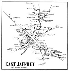
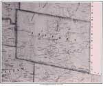 Click here to view Jaffrey (town-wide) portion from the Map of Cheshire County, 1858.
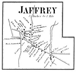
Click here to view [Jaffrey Center] portion from the Map of Cheshire County, 1858.
Click here Mt. Monadnock. View from the Map of Cheshire County, 1858. Click here School House in District No. 2. View from Map of Cheshire County, 1858. |