Maps > 1980 Highways Map
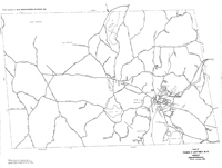
Plan of Town of Jaffrey, N.H. HighwaysThis map of Jaffrey appears to have been produced by the Jaffrey Highway Department. It is essentially a map of the roads and highways of Jaffrey. Also shown are major lakes and ponds and the Boston and Maine Railroad. In the upper left corner there appears: "Printed compliments of: W.W. Cross Division, PCI Group, Inc." In the lower left corner there appears a Note or Legend that identifies roads as: "Plotted from Actual Surveys; Plotted from U.S.G.S. Sheets 1"=1/2 mile; Class VI Roads as of October 1980." |
Click here to download and view a pdf of the Plan of Town of Jaffrey, N.H. Highways (October 1980).
|