Maps > 1982 Kidd
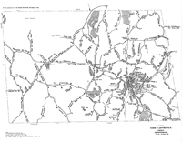
Map of Jaffrey to accompany Jaffrey Roads and Streets 1773-1980 (Kidd)The base for this map which accompanied Coburn Kidd's Jaffrey Roads and Streets 1773-1980 (Jaffrey Historical Society, 1982) is the one titled Plan of Town of Jaffrey, NH Highways which was produced by the Town in 1980. Kidd has made handwritten additions to the map: mainly, houses marked on 1898 U.S. Coast & Geodetic Survey Map (actually USGS is meant) and road names. Also some features such as ponds. |
Click here to download and view a pdf of the map that accompanies Jaffrey Roads and Streets 1773-1980 ( 1982).
|