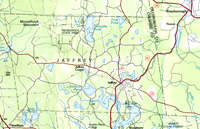
1984 Made-up Map of Jaffrey, N.H.
This 'made-up' map of Jaffrey was produced by JaffreyHistory.org by combining sections of two maps resulting in a single map of Jaffrey, this being because the coverage for Jaffrey is split by the two maps. The two maps in questions are:
1) Lowell Massachusetts New Hampshire 1:100,000 scale planimetric map. 42071-E1-PL-100. 30x60 minute quadrangle. Date: 1984.
Compiled from USGS 1:24,000-, 1:25,000-, and 1:62,500-scale topographic maps dated 1953-1979. Planimetry revised from aerial photographs taken 1978 and other source data. Revised information not field checked.
Projection and 10,000-meter grid, zone 19: Universal Transverse Mercator.
25,000-foot grid ticks based on New Hampshire coordinate system and Massachusetts coordinate system, mainland zone.
Elevations shown to the nearest meter.
To convert meters to feet multiply by 3.2808.
To convert feet to meters multiply by 0.3048.
1) Keene NH, VT MASS 1:100,000 scale planimetric map. 42072-E1-PL-100. 30x60 minute quadrangle.
Date: 1986.
Compiled from USGS 1:24,000- and 1:62,500-scale topographic maps dated 1954-1984. Planimetry revised from aerial photographs taken 1983 and other source data. Revised information not field checked.
Projection and 10,000-meter grid, zone 18: Universal Transverse Mercator.
25,000-foot grid ticks based on Massachusetts coordinate system, mainland zone, and New Hampshire and Vermont coordinate systems.
1927 North American Datum.
Elevations shown to the nearest meter.
To convert meters to feet multiply by 3.2808.
To convert feet to meters multiply by 0.3048.
|
| Title: |
Made-up map of Jaffrey, N.H. |
| Compiler: |
USGS |
| Date: |
Lowell (1984)
Keene (1986) |
| Place: |
Reston, Virginia |
| Publisher: |
US Geological Survey |
| Scale: |
1:100,000 |
| Size: |
The two sheets are each 24 x 24 inches. |
| Notes: |
See to the left. |
Click here to download and view a pdf of the 1:100,000 planimetric map of Jaffrey (1984, 1986).
Two sources for historical USGS maps of New Hampshire or other New England states are Maptech and the University of New Hampshire.
|