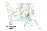
2007 Base MapThis map of Jaffrey is derived from a map titled Water Distributon System, Town of Jaffrey, New Hampshire that was prepared by Tighe & Bond, Consulting Engineers. It appears to use the base map prepared by Cartographic Associates. Data pertaining to the water system have been removed. Shown are streets and highways, ponds, lakes and wetlands, rivers and streams, lot boundaries and utility easements. A portion of Rindge is also included which is explained by the fact that Jaffrey's water distribution system serves a small portion of Rindge. |
Click here to download and view a pdf of the Jaffrey Base Map (2007).
|