Maps
Most New Hampshire towns south of the White Mountains were mapped as part of the campaign against the White Pine Blister Rust, a fungal pest found on seedlings that were imported from Europe as part of a reforsestation effort in the early 1900s.
"Foresters and loggers recognized the threat posed by blister rust as soon as it appeared in 1909. By 1922, the blight had spread to as many as half the white pines in some areas of New Hampshire. Blister rust spread rapidly, and its destructive potential was enormous. But…the disease also has one critical weakness. It’s a disease that has an alternate host, the life cycle is such that it spreads from ribes, which is the genus name of gooseberries and currants. This disease, because it has an alternate host, is able to be eliminated by eliminating one of the hosts…As early as 1917, New Hampshire outlawed the sale or planting of gooseberries, currants, or any other ribes species. And the state began a long series of ribes eradication programs that would last until the late 1970s."
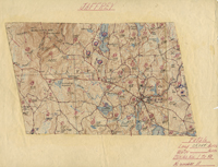
To plan and evaluate the eradication effort, extensive mapping was undertaken, first by Civilian Conservation Corpsmen, then later by the NH State Division of Forests and Lands. This was repeated often on a ten-year cycle.
"No other maps of New Hampshire carry the foot-by-foot detail of the blister rust maps. They record the landscape layout and its forest composition exactly as it was in the 30s, 40s, 50s, 60s, and even 70s. Many of them are works of art, beautifully inked and colored. Most were drawn before redevelopment began to erase the fields, forests, and meadows that had defined New Hampshire’s past. Thus, they reveal patterns of settlement and use that date to the 18th and 19th centuries."
The first Jaffrey maps were produced during the summer of 1927. The last full mapping appears to have been accompkished in 1949. Among those working on the mapping program in Jaffrey were Charlie and Kent Royce.
Note: The quoted material above has its source in a NHPR broadcast by Kevin Gardner entitled "State's Past Captured in Disease Control Maps" which aired on 3 February 2003. The full transcript may be read at http://www.nhpr.org/node/4452
|
| Title: |
Jaffrey Pine Blister Rust Maps |
| Compiler: |
L. B. Hackett and others |
| Date: |
1927 and later |
| Place: |
Jaffrey |
| Publisher: |
Manuscript |
| Scale: |
6" = 1 mile |
| Size: |
8 x 10" |
| Notes: |
See to the left. |
Mini-view of the Map

Click here to view a jpg file of the the index map showing the 47 sections of Jaffrey. The following detailed maps are available as .pdfs.
Click here to download Block 1.pdf.
Click here to download Block 2.1.7.pdf.
Click here to download Block 2.2.pdf.
Click here to download Block 3.4.2.pdf.
Click here to download Block 4.1.pdf.
Click here to download Block 4.3.pdf.
Click here to download Block 8.1.pdf.
Click here to download Block 8.2.pdf.
Click here to download Block 8.3.pdf.
Click here to download and view the Type Legend for these maps.
|

